Are We There Yet?
/Teams Led By OSU Scientist Seek To Discover Answers On Climate Change At Petermann Glacier In Greenland
by Carol Hasenberg
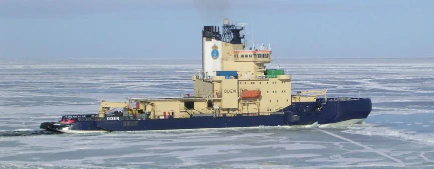
Photo of Oden by Laurence Dyke,
Dr. Alan Mix, Professor of Oceanography in the divisions of Ocean Ecology and Biogeochemistry and of Geology and Geophysics in the College of Earth, Ocean, and Atmospheric Sciences at Oregon State University and Chief Scientist of the Petermann Glacier 2015 research expedition, spoke at the GSOC 81st Annual Banquet about the research he led at Petermann Glacier in Greenland. His talk stressed the value of the research in helping to further our understanding of climate change and drive the political policies needed to help us face the changes.
As it becomes more certain that global, human activity-generated climate change is a reality, US policy makers and their counterparts in other parts of the world have been working to get information about anticipated changes in the climate. How much of a change are we talking about, in terms of surface, atmospheric, and oceanic warming, melting of polar ice caps, sea level changes, ocean current changes, and other effects? How fast are these changes anticipated, and what effects can be prevented by government policies? What should our policies be over the next several decades to best prepare our countries for the effects of climate change?
All big questions, and questions that are not easy to answer. With the development of computers, climate simulation and prediction models have been developed over the last several decades. These models have gradually increased in complexity, always straining at the limits of computational power. In his talk Alan Mix showed a number of slides of the results of climate models to date. These model results can be reviewed by the readers in the Intergovernmental Panel on Climate Change (IPCC) 5th Assessment Report (2014). The IPCC, established by the United Nations Environment Programme (UNEP) and the World Meteorological Organization (WMO) in 1988, is the leading international body for the assessment of climate change.

The climate simulation model results shown in the IPCC report show a high confidence of accuracy for global climate effects from about 1900 to the present. Many complex environmental interactions are simulated in these models. Over the past couple decades the models have shown significant improvement in their accuracy modeling known climate parameters from the past century, although some minor climate deviations have yet to be simulated. Ultimately the models must be accurate enough to be used for climate prediction and policy decision making. So far climate prediction models have been made for near future trends, and most do not show predictions beyond the year 2100. In order to calibrate long term climatic prediction models, the scientific community is turning to paleoclimatic data to help them simulate long term climatic trends. The project at Petermann Glacier was funded by the National Science Foundation and the Swedish Polar Research Secretariat in order to gather paleoclimatic data from a crucially important part of the world, the Greenland Ice Sheet.
In his discussion of the importance of the Greenland Ice Sheet, Mix stressed two results of melting the sheet that could significantly affect climate and human habitation of the planet: the rise in mean sea level, and the effect of so much fresh water being introduced into the North Atlantic and its effect on oceanic circulation currents. The Greenland Ice Sheet is the smallest of the three polar ice sheets (the other two are West and East Antarctica) and the first to possibly melt. Currently the Greenland Ice Sheet is exhibiting a net mass loss, mainly due to the draining of ice through outlet glaciers such as Petermann. Policy strategy must be based upon whether or not it is too late to stop the melting of the Greenland Ice Cap. Mix displayed model result graphs from the IPCC report which showed that we are approaching the zone where the melting is inevitable, without signs of world carbon dioxide production slowing. One positive factor in the melting of the Greenland Ice Sheet is that it seems to be occurring more slowly than originally thought; current research points to the melting occurring over a period of about one thousand years, rather than in the current century.
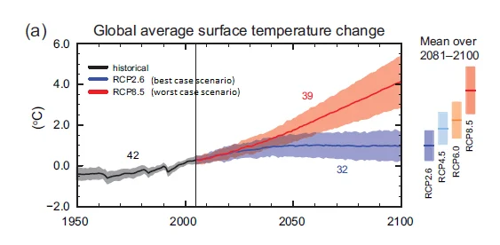
Figure SPM.7a Multi-model simulated time series from 1950 to 2100 for change in global annual mean surface temperature relative to 1986–2005, adapted from IPCC, 2013: Summary for Policymakers. In: Climate Change 2013: The Physical Science Basis. Contribution of Working Group I to the Fifth Assessment Report of the Intergovernmental Panel on Climate Change [Stocker, T.F., D. Qin, G.-K. Plattner, M. Tignor, S.K. Allen, J. Boschung, A. Nauels, Y. Xia, V. Bex and P.M. Midgley (eds.)]. Cambridge University Press, Cambridge, United Kingdom and New York, NY, USA.
Mix also explained that current climate models predict that the effects of the greenhouse gas infusion will ramp up more slowly than originally thought and there still is time to reduce the effects by reducing our carbon footprint; however, it will take millennia for carbon dioxide to return to preindustrial levels and humanity will be living with its effects for a long, long time. For example, Mix stated that predictions of sea level rise in the next 100 years are not as dramatic as atmospheric changes because of the length of time it takes to melt the ice. It appears that we can limit the sea level rise to 10 to 20 meters in 1000 years if good policies are in place, otherwise the future change will be greater than sea walls can solve.
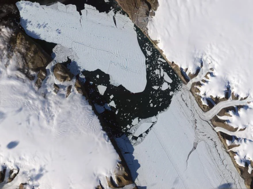
Photo by NASA of the 2010 calving event at Petermann Glacier.
Petermann Glacier is one of the largest outlet glaciers draining ice from the Greenland Ice Sheet, and it is situated on the northwest side of the subcontinent. It lies along the Nares Strait, which runs between Greenland and Ellesmere Island. Petermann Fjord which contains the glacier is very deep, and the seaward section of the glacier is floating on water in the fjord. This floating ice shelf helps buttress the ice sheet behind it. As they were writing the proposal for the 2015 expedition to Petermann, the ice shelf experienced two major calving episodes, one in 2010 and another in 2012. Petermann Glacier is one of the most difficult places on earth to access.
The research team that participated in the Petermann 2015 expedition was comprised of about 80 individuals, with Oregon State University and Stockholm University heavily represented. Oregon State University has become one of the world’s top research facilities for marine science and climate change. Other members of the expedition included a smattering of other American and Swedish academic researchers, members of the British Antarctic Survey and other technical experts needed for the project’s particulars. The expedition sailed on the Swedish icebreaker Oden from the port of Thule, Greenland, and the time frame for the expedition was one month, August 2015, after about a decade of planning.
The goals of the Petermann 2015 Expedition were to collect paleo data on the extent of the glacier at particular times in the past, sample the current conditions of the water in the fjord and adjacent Nares Strait, and to make detailed bathymetry maps for future expeditions. Upon arrival in the fjord the ocean mapping team of the expedition used echo sounding equipment to prepare the bathymetry maps as the Oden moved up and down in parallel tracks in the fjord “mowing the lawn”. Or as near as they could get to such an ideal in the windy, ice strewn environment. After this important task the other exploration teams got up and running to collect the data.
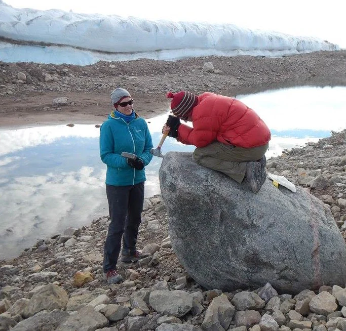
Boulder team sampling its wares. From “Boulder Sampling Alongside Petermann Glacier; camping logistics and lateral moraines,” article posted on Petermann’s Glacial History website by Elizabeth Ceperley and Melissa Reusche of University of Wisconsin, Madison.
Some of the teams worked away from the ship. The ice drilling team worked at several points on the ice shelf, and at the point where the glacier became the ice shelf, called the grounding point. They used hot water to drill through the ice shelf, which was 200-300 meters thick. They sampled the water below the ice shelf and also drilled core samples of the fjord bottom below the ice shelf. The water below the ice shelf was warmer than expected and teaming with life. It became clear that the ocean is melting the glacier and not the atmosphere.
Another team went on land to look for clues of the retreat of the glaciers. They found fossil clam shells to radiocarbon date, and also chipped samples from glacially-deposited erratic boulders in order to determine their concentration of the nuclide beryllium10, which decreases the longer the sample is exposed to the bombardment of cosmic radiation. They also noted physical features such as stream terracing to make a complete of a picture as they could of the positions and times of the glacial retreat.
Several teams worked aboard the Oden collecting data and samples. A seismic reflection team used high frequency sound emitters and a battery of receivers to make a profile of the earth’s crust below the fjord in order to analyze the stratigraphy below the water. Core samples were collected, especially at points in the past where the ice shelf had been grounded, which could be determined by studying the bathymetry maps generated by the expedition. Many samples were taken in different locations of the water in the fjord and Nares Strait so that ocean currents in the area could be better understood.
After an extremely busy month, the expedition took its leave of the fjord and headed back to Thule. Mix expressed a hope for the expedition to return to Petermann next year. He thought that it also might be possible to bring guests in future trips which might help to get the word out on what the group is trying to accomplish. This past year a filming team from 60 Minutes went to Petermann for 2 days at a cost of about $250,000. The reader is encouraged to read the Petermann’s Glacial History website for more details.


